Perilfinder™ allows the underwriter to work faster and with greater flexibility, it also ensures a greater confidence when writing new business.
The 2.0 version, released today, provides enhanced reporting and data analytics, and is set to be a key differentiator in the way insurers operate!
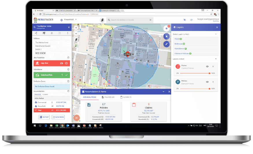
What’s new?
- Layered view of different perils: Flood, Subsidence, Crime, Fire, Storm, etc.
- Layered view of accumulations, policies and claims.
- You can easily filter policies with high exposure.
- New Solvency II Reporting.
- Updated Reports: Risk Reports, Accumulation Reports, Accumulation Change Reports, Policy Reports, Peril Reports, Reporting Web Service.
The ability to assess various perils and accumulations at the point of underwriting provides the insurers with actionable information, improving the risk selection process and lowering the cost of claims.
Key Benefits:
- Instant access to geographic risk data.
- Automatic display of RAG (Red, Amber, or Green) flags based on the peril score settings for an address.
- Real-time rating and pricing.
- Assess risk by overlaying relevant peril maps such as Flood, Subsidence, Crime, Fire, Storm and other perils.
- Determine accumulation geographically in real time.
- Detect fraudulent claims accurately.
- Evaluate outcomes of a potential catastrophe in real-time.
- Understand the likelihood of damage before and immediately after an event.
- Facility to overlay key services such as fire stations, police stations.
- Ability to interrogate any policy or another dataset element on the map and display information about the entity.
Perilfinder™ supports both decisions at the point of sale and in the back office, through custom user-specific dashboards and tools.