Boundaries

Share on twitter
Share on linkedin

Location. Intelligence.

The recent publication of the Residential Property Price Index by the CSO is notable for a number of reasons. The revised methodology for generating the dataset has provoked much discussion, and the interactive tool looks useful. One facet of the data which is of particular interest to those working in the field of Location Intelligence is that the data is available for a number of geographies, including by Eircode Routing Key. This is the first time that data has been published at that level by a public data producer in Ireland.

The use of Routing Key level geography is understandable, as it’s very quick and easy to group the data by simply looking up the first three characters of the Eircode, and the areas themselves are sufficiently large to avoid privacy concerns. However, as a boundary dataset the routing keys do leave something to be desired. Firstly there is considerable variance in size, both in terms of area and population across the dataset. Routing key areas cross county boundaries, and are non-contiguous, with some routing keys being split into two non-adjoining parts.

Routing keys in Cork, note there are two areas labelled P51.

At GAMMA we prefer to use Small Areas (SA’s) as their small size reveals patterns in the data that is masked when using larger areas such as counties, we use them for everything from area profiling to customer analytics. They are also included as a table in the ECAD database from Eircode.

SA’s do not have names, and their ID numbers can be a little bit unwieldy, so AutoAddress have developed a version of the SA dataset which groups nearby SA’s together and gives them shorter code names, making them ideal for logistics companies, a number of which are now implementing solutions using these. The AutoAddress App is currently being used by couriers over 30,000 times per month.

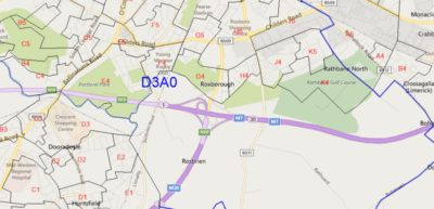
AutoAddress Delivery Zones in Limerick.

There are lots of different boundary datasets available for Ireland, official boundary data is available as Open Data from data.gov.ie. In all there are 90 data publishing organisations and over 4,000 datasets on the site, and this number is increasing every week.

In addition to official boundaries many organisations apply intelligence to their location data, defining their own trading areas, catchments, franchise territories, service zones and so on. In short, there are an infinite number of ways of dividing up the country.

One of the crucial aspects of Eircode is that it a point based dataset. Every Eircode has a grid-coordinate. That means that no matter which boundary dataset is used you can aggregate your eircoded data into it. That is something which is simply not possible with area based postcode systems, such as that used in the UK, or with grid based systems either.

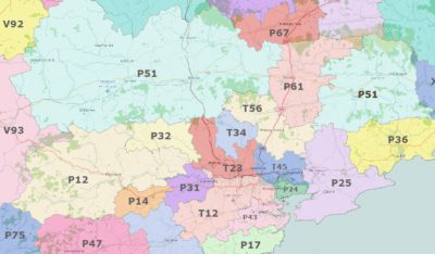
We have built a dataset of Eircode Routing Key boundaries from the SA dataset, they can be downloaded from here.

Please note these are not official boundaries, An Post do not use boundaries to define a Routing Key for a property.

This is a short version of a Gamma White Paper on Boundaries which can be viewed here.

@ 2016 Gamma.ie by Richard Cantwell

About Gamma 

Gamma is a Location Intelligence (LI) solutions provider; we integrate software, data and services to help our clients reduce risk through better decision-making. Gamma was established in 1993 and was the first company to develop LI for the private sector in Ireland. The company has expanded to become a global provider of cloud-hosted LI systems, micro-marketing solutions and related services.